"Water is the driving force of all nature." — Leonardo da Vinci
Understanding river basins is not just geography — it is understanding the lifeline of civilizations.
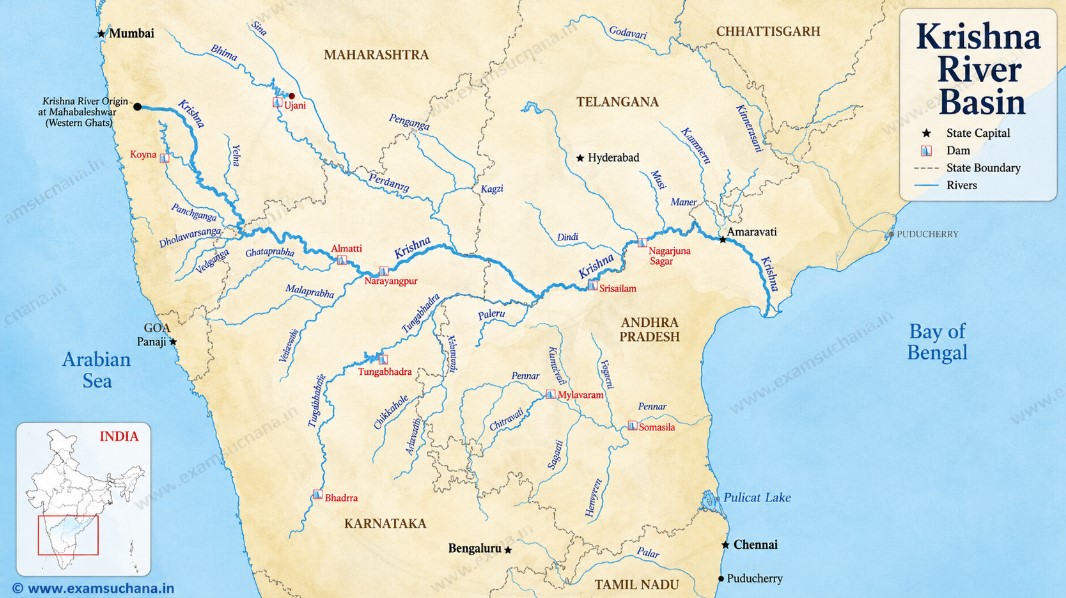
Why Krishna Basin Matters
The Krishna River Basin is one of the most strategically and hydrologically significant river systems in Peninsular India. For UPSC, MPSC, and competitive exam aspirants from Maharashtra, understanding this basin is essential — not just as a geographical fact, but as a dynamic intersection of ecology, inter-state politics, agriculture, and water governance.
The Krishna River, known as Krishnaveni in classical texts, is the third largest river in India by length and the second largest east-flowing river in the Deccan Plateau. It originates in Maharashtra and journeys across three other states before draining into the Bay of Bengal — making it both a local and national issue.
Origin and Physical Journey
The Krishna River originates at Mahabaleshwar in the Satara district of Maharashtra, at an elevation of approximately 1,337 metres above sea level in the Western Ghats. It is born from a small spring near the ancient Panchganga Temple at Mahabaleshwar — a sacred site where five rivers are believed to originate.
From Mahabaleshwar, the river flows:
- Eastward through Maharashtra's drought-prone Marathwada and Solapur regions
- Then into Karnataka (Bijapur, Raichur)
- Further into Telangana (Nalgonda, Mahbubnagar)
- Finally into Andhra Pradesh, where it meets the Bay of Bengal near Hamasaladeevi in Krishna district
Total length: ~1,400 km
Total basin area: ~2,58,948 sq km
Maharashtra's share of basin area: Approximately 69,425 sq km (~26.8% of total basin)
Major Tributaries in Maharashtra
The Krishna Basin in Maharashtra (Rivers in Maharashtra) is fed by several important tributaries. Understanding these is critical for questions on irrigation, dam projects, and drought management.
Left Bank Tributaries (join from the north):
| Tributary | Origin | Key Feature |
|---|---|---|
| Bhima | Bhimashankar, Pune | Longest tributary; passes through Solapur |
| Sina | Ahmednagar | Key for Marathwada irrigation |
| Mana | Satara hills | Smaller seasonal stream |
Right Bank Tributaries (join from the south):
| Tributary | Origin | Key Feature |
|---|---|---|
| Koyna | Mahabaleshwar hills | Powers Koyna Hydroelectric Project |
| Varna | Western Ghats, Kolhapur | Feeds sugarcane belt |
| Panchganga | Confluence near Kolhapur | Culturally and ecologically significant |
| Dudhganga | Amboli Ghat, Kolhapur | Flows into Panchganga |
Educator's Insight: The Bhima River is sometimes confused with the main Krishna. Remember — Bhima is the largest tributary of Krishna, not Krishna itself. In exams, questions often test this distinction.
Major Dams and Irrigation Projects in Maharashtra
Maharashtra has constructed several dams within the Krishna basin to harness water for irrigation, drinking, and power generation.
1. Koyna Dam (Shivajisagar Lake)
- Located in Satara district
- One of the largest dams in Maharashtra
- Primarily built for the Koyna Hydroelectric Project — generating ~1,960 MW of power
- Also supplies drinking water to parts of Konkan and Western Maharashtra
- The region gained infamy after the 1967 Koyna Earthquake (6.5 magnitude) — a classic example of Reservoir-Induced Seismicity (RIS)
2. Urmodi Dam
- Located on the Urmodi River (tributary of Koyna), Satara district
- Used for irrigation in the Krishna sub-basin
3. Dhom Dam
- Located near Wai, Satara on the Krishna River itself
- Supplies drinking water to Satara city and surrounding villages
4. Warna Dam
- On the Warna River, Kolhapur district
- Crucial for the sugarcane belt of southern Maharashtra
5. Ujani Dam (Bhima River)
- Located in Solapur district on the Bhima (tributary of Krishna)
- One of the largest reservoirs in Maharashtra by capacity
- Serves the drought-prone Marathwada and Solapur regions
Inter-State Water Dispute: The Krishna Water Tribunal
The Krishna River is shared between Maharashtra, Karnataka, Andhra Pradesh, and Telangana. The allocation of its waters has been a source of intense inter-state rivalry.
Krishna Water Disputes Tribunal – I (KWDT-I)
- Constituted in 1969 under the Inter-State River Water Disputes Act, 1956
- Gave its final award in 1976
- Allocation:
- Maharashtra: 560 TMC (Thousand Million Cubic feet)
- Karnataka: 700 TMC
- Andhra Pradesh: 800 TMC
Krishna Water Disputes Tribunal – II (KWDT-II)
- Constituted in 2004 after Andhra Pradesh sought re-allocation
- The bifurcation of Andhra Pradesh in 2014 created Telangana as a new claimant state, further complicating matters
- Final award is still under legal scrutiny in the Supreme Court of India
Educator's Insight: The Krishna water dispute is a model case study for understanding Articles 262 of the Indian Constitution and the Inter-State River Water Disputes Act, 1956. Never mix KWDT-I (1969) with Bachawat Tribunal (Indus) or Godavari Tribunal.
Climatic and Agricultural Significance
The Krishna basin in Maharashtra spans multiple agro-climatic zones:
- Western part (Satara, Kolhapur): High rainfall (2,000–3,000 mm), fertile black soil — supports sugarcane, rice, and horticulture
- Eastern part (Solapur, parts of Sangli and Marathwada): Semi-arid, rainfall below 600 mm — heavily dependent on canal irrigation from Ujani and other dams
The basin contributes significantly to Maharashtra's:
- Sugarcane production (especially Kolhapur and Sangli)
- Grape cultivation (Sangli and Nashik fringe areas)
- Jowar and Bajra cultivation in drier sub-basins
Environmental and Ecological Concerns
The Krishna Basin in Maharashtra faces multiple ecological pressures:
- Pollution: Industrial effluents from Sangli, Kolhapur, and Pune region (Bhima sub-basin) severely degrade water quality
- Sand Mining: Illegal sand mining along the Krishna and Bhima threatens river morphology
- Reservoir-Induced Seismicity: Koyna dam area remains seismically sensitive
- Shrinking Wetlands: The Ujani backwaters host migratory birds but face threats from water hyacinth and encroachment
- Climate Change Impact: Erratic monsoons are causing increased drought years in eastern Krishna sub-basin
Recent Developments (2023–2025)
- Marathwada Water Grid Project: Maharashtra government has proposed linking Krishna tributaries with Marathwada's water-stressed areas through a pipeline grid
- KWDT-II Award Implementation: Ongoing disputes between Maharashtra, Karnataka, and the newly bifurcated Telangana remain before the Supreme Court
- Jal Jeevan Mission: Several villages in the Krishna basin area are being covered under this national drinking water scheme
Quick Revision Summary
| Parameter | Details |
|---|---|
| Origin | Mahabaleshwar, Satara, Maharashtra |
| Elevation at Source | ~1,337 m |
| Total Length | ~1,400 km |
| States Covered | Maharashtra, Karnataka, Telangana, Andhra Pradesh |
| Drains Into | Bay of Bengal |
| Maharashtra Basin Area | ~69,425 sq km |
| Key Tributary | Bhima River |
| Major Dam in MH | Koyna Dam (Satara) |
| Hydropower | Koyna HEP (~1,960 MW) |
| Water Tribunal | KWDT-I (1969), KWDT-II (2004) |
| MH Water Share (KWDT-I) | 560 TMC |
Practice MCQs
- For MPSC/UPSC aspirants: Always link Krishna Basin questions to inter-state disputes (Art. 262), water governance, Jal Shakti Ministry, and Maharashtra's drought policy for comprehensive answers in mains.*